03/10/2009
ArcImaging - The Search For Noah's Ark
GIS – Geographic Info. System
 Geolocate using GIS database
 Links to data, photos, video, audio
reports
Identify key areas of interest
Utilize existing data
Satellite Photos
Previous expedition photos
Post mission data
Much post-expedition analysis
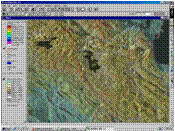
Remote
Sensing scientist can take two-dimensional
maps and make them into
three-dimensional – show example
Links to data, photos, video, audio
reports
Identify key areas of interest
Utilize existing data
Satellite Photos
Previous expedition photos
Post mission data
Much post-expedition analysis
Remote
Sensing scientist can take two-dimensional
maps and make them into
three-dimensional – show example